Latitude: N 35°55'08"
Longitude: W 120°28'56"
Length: 850.8m
Number of Bench marks: 36
Number of Surveys to 2000: 12
Date of Initial Survey: 6 April 1984
Date of Latest Survey: 12 September 1996
Trespass Permission: Permission to trespass required of property owner.
Directions:
From the bridge at Parkfield, drive northwest on Vineyard Canyon Road 4.0 miles
to a gate on the north side of the road marked only by a sign that says "Pomona".
BM PR01 is on the south side of Vineyard Canyon Road. Go through a barbwire
strap fence gate opposite the Pitt Ranch gate and walk southwest, perpendicular
to the road to PR01.
Comments:
This line was established by the U.S. Geological Survey as a tilt array on the
southwest side of the San Andreas fault, three miles WNW of Parkfield. UCSB
set an additional bench mark between each of the USGS bench marks in June 1984.
Results:
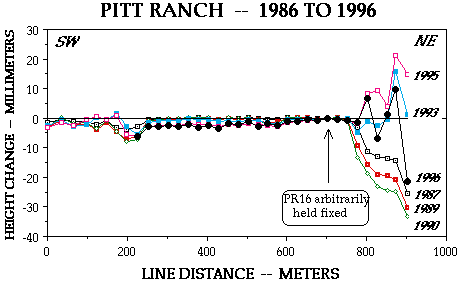
For much of its length, the line has been remarkable stable since April 1984,
but six bench marks at the northeast end of the line have subsided progressively
more than 30 mm to June 1990, and then they rose back to nearly initial levels
in 1993 and 1995. Those bench marks are on poorly consolidated siltstone, whereas
the remainder are on alluvium of an alluvial fan that heads near the northeast
end of the line. One may postulate that the six bench marks lie on the northeast
side of a fault that bounds the southwest flank of Middle Mountain, and that
the Middle Mountain is subsiding relative to Cholame Valley. It is more likely
that the siltstone is dehydrating and subsiding thereby as a result of the 1986-1991
drought. The rebound of the six bench marks in 1993 and 1995 reflects
rehydration following wet winters since 1992.
Reference:
Sylvester, A. G., 1995. Nearfield vertical displacement in the creeping segment
of the San Andreas fault, central California, 1975 to 1994. Tectonophysics 247,
25-47.

Up one level
Return to the Title Page.