GRAND TETON Leveling Line
| Latitude: N 43°42'32 Longitude: W 110°42'38 |
Length: 22,145.5m Number of Bench marks: 50 |
| Number of Surveys to 2002: 6 Date of Initial Survey: Aug/Sep 1988 Date of Latest Survey: August 2001 |
Trespass Permission: Resource Manager Grand Teton National Park, Moose, Wyoming |
| Directions: The line commences at the top of the bluff overlooking Deadman Bar on the west bank of the Snake River; it proceeds westward across Baseline Flats to Jenny Lake; thence around the south side of the lake via the horse trail; thence up the horse trail into Cascade Canyon to the forks and as far as the ranger cabin in North Fork. |
|
Comments: The fifth and sixth resurveys were done in 1997 and 2001 by 9 volunteers associated with the University Research Expeditions Program (UREP) under the supervision of Arthur G. Sylvester and Christopher S. Hitchcock. The 1997 participants were Erin Bower, Kenneth Craig, Yee-Bien Chuah, Mark Hughes, Curtis Joe, Jennifer Caci, Randy Kahn, and Louis and Lucia Fermelia. The 2001 participants were Rob Haworth, Fred Howe, Gil Kane, Falene Petrik, Randa Hope, Allison Leonard, Emily Crawford, Thomas Neely, and Madeline Goff - assisted by University of Utah students Aaron DeNosaquo and Wu Lung Chang, with Susan Dougherty and Lisa Gartland providing essential support. |
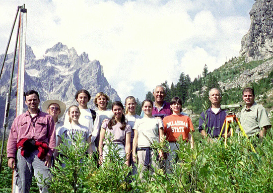 |
| UREP surveying team, Grand Teton National Park, 2001. From left to right, Christopher, Gil, Allison, Aaron, Thomas, Madeline, Falene, Emily, Fred, Randa, AGS, Rob. More images of this crew. |
|
Abstract for 2001 Fall AGU Meeting, San Francisco
A. G. Sylvester (Univ. California, Santa Barbara CA), R. B. Smith and Wu Lung Chang (Univ. Utah, Salt Lake City, UT), C. S. Hitchcock (Wm. Lettis & Assoc., Inc., Walnut Creek, CA), and J. O. D. Byrd (Anadarko Petroleum., Houston, TX) As part of a comprehensive neotectonic study of interseismic behavior of active faults, we have done six first order leveling surveys of 50 permanent bench marks in a 22 km-long base line across the Teton fault to characterize its interseismic behavior between 1988 and 2001. This 55 km-long normal fault extends along the eastern base of the Teton Range, exhibits up to 30 m of post-glacial offset, and has one the highest rates of Holocene slip of any fault in the Basin-Range. It is seismically dormant at the M2+ level, however, and presently lies in the center of a 50 km-long seismic gap. Results of five of the six levelings are remarkably similar and suggest that the alluvium-filled valley of northern Jackson Hole (hanging wall) subsided 6-8 mm relative to bedrock of the Teton Range (footwall) relative to the 1989 survey. In 1997, however, a 2 km-wide zone adjacent to the fault rose 12 mm relative to the 1993 survey, and then dropped 16 mm by the 2001 leveling. This zone coincides with an area of low topography characterized by lakes ponded along the fault and south-flowing streams parallel to the range front, rather than eastward away from the range. This subsidence zone records hanging wall subsidence related to long term faulting. The 1997 uplift of the valley floor and subsidence zone may reflect an unexpected, reverse loading and local crustal shortening between 1993 and 2001. Campaign GPS surveys (1987 to 2000) support this hypothesis, indicating that the principal horizontal strain axis is locally E-W perpendicular to the fault, and suggesting crustal shortening occurred in the period 1995-2000. Regionally during 1987-1995, subsidence and contraction characterized deformation of the Yellowstone caldera only 30 km to the north, when GPS recorded uplift and extension across the Teton fault. During 1995-2000, subsidence slowed or ceased for much of the caldera, whereas the overall GPS vectors across Jackson Hole were directed west with almost 2 mm/yr of E-W motion (N. America fixed). This strain field would load the east-dipping Teton normal fault in contraction, implying that the regional stress field was compressional against the fault at the time of the 2000 GPS survey. The return of the 2001 leveling signal to pre-1997 values suggests that the strain reversed, and that the 1997 leveling anomaly was a contractile strain transient that passed across the fault probably between 1995 when the strain pattern at Yellowstone caldera changed and the 2000 GPS survey, but before the 2001 leveling. Preliminary elastic dislocation models indicate 10-20 mm reverse slip at a depth of 1-2 km. Alternatively the observed leveling changes may reflect a complex combination of other processes including local poroelastic effects, or nearfield drag of the hangingwall as it subsides overall in farfield extension. Funded by NSF, NEHRP, UREP, UW/NPS Research Station, Teton Science School Funded by NSF, NEHRP, NPS, UREP, NPS/UW Research Station, and Teton Science School |
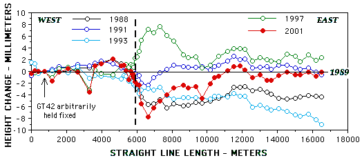
| Graph of height changes among permanent bench marks in leveling base line across Teton normal fault in Grand Teton National Park. Graph assumes 1989 survey as the datum, bench mark GT42 is arbitrarily held fixed. The fault is depicted as the vertical dashed line - the Teton Range (footwall) is west of the fault, the north part of Jackson Hole (hanging wall) is east of the fault. Uncertainty of bench mark heights in each survey is about equivalent to the diameter of each dot or circle. Standard deviation of bench mark heights per kilometer of leveling is 0.08 mm. The data are extrapolated into a 17 km-long straight line that extends from GT01 at the Snake River near Deadman Bar to GT44 in the core of the Teton Range. The traverse path distance is 22.1 km. |
|
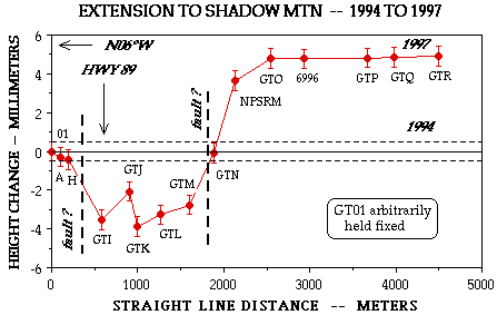
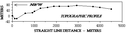
EXTENSION TO SHADOW MOUNTAIN We resurveyed the extension of the original leveling line in August 1997 with the result shown in the graph below. The data are extrapolated into a straight line that trends N06°W, in contrast to the main line that trends N87°W. GT01 of the main line is arbitrarily held fixed and is at the north end of the extended line in this graph. Since 1994, five bench marks subsided about 3 mm relative to GT01, whereas five at the south end of the line rose 5 mm. GTJ, among the five that subsided, is a bench mark in a large rock on the floor of a small canyon - it may not be stable. The five bench marks at the south end of the line are in a thin layer of alluvium on the west flank of Shadow Mountain. The queried faults coincide with topographic lineaments, including the front of Shadow Mountain. The displacements do not reflect the topographic profile, indicating that the faults are young or that any topographic expression they may have had has been modified by erosion. |
|
References: Sylvester, A. G., J. O. D. Byrd, and R. B. Smith, 1991. Geodetic evidence for aseismic reverse creep across the Teton fault, Teton Range, Wyoming. Geophysical Research Letters 18 (6), 1083-1086.
Sylvester, A. G., 1996. Snake River, Wyoming, crossing with the Leica NA3000 digital level. Survey Review 33, 383-388. Sylvester, A. G., R. B. Smith, C. S. Hitchcock, and J. O. D. Byrd, 1997. Interseismic hanging wall uplift on Teton normal fault, Grand Teton National Park Wyoming, 1988-1997, measured by precise leveling, pp. 69-73, in Harlow, H. J., editor, 21st Annual Report, University of Wyoming/NationalPark Service Research Center, 137 p. Sylvester, A.G., Byrd, J.O.D., and Smith, R.B., 1997. Geodetic Evidence and Possible Mechanisms for Aseismic Height Changes Across the Teton fault, Wyoming..Abstracts with Programs, Geological Society of America, Ann. Meeting, Salt Lake City. Sylvester, A. G., 1997. Byrd, J. O., A. G. Sylvester, R. B. Smith, and C. S. Hitchcock, 1997. Interseismic hanging wall uplift on Teton normal fault, Grand Teton National Park, Wyoming, 1988-1997, measured by precise leveling. EOS Transactions, American Geophysical Union 78 (46), 158. |
Return to the Leveling Page. | Up one level | Return to the Title Page. | Go to Crew Photos